Combatting the Urban Heat Island Effect with UAV Thermal Imaging – Part 1
Keenan Gibbons is a licensed landscape architect and urban design professional at SmithGroup. His professional expertise is in the sustainable planning, design and implementation of green infrastructure, parks, streetscapes and creative stormwater management strategies. He is also an FAA-certified Remote Pilot. At SmithGroup we are exploring the new frontier of UAV (drone) data to evaluate built environments for heat island impacts while discovering ways to help cities better adapt to climate change. Keenan is helping the firm lead this charge.
UNDERSTANDING THE URBAN HEAT ISLAND EFFECT
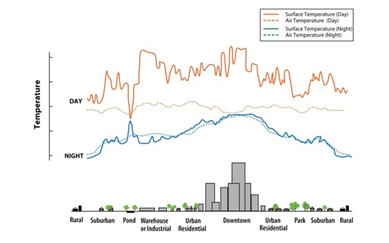
Cities around the globe continue to become larger, hotter and more congested. On a warm summer day we have all felt the difference between a sweltering hot parking lot versus the forgiving shade of a tree. This is an example of the urban heat island effect.
SmithGroup’s Urban Design practice creates innovative streetscapes, rooftops and public spaces every day. As urban realm experts, we routinely apply green infrastructure principles to address environmental issues that directly combat the urban heat island effect.
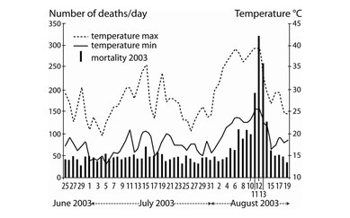
The urban heat island first gained notoriety after 30,000 deaths were attributed to the 2003 European heat wave, 14,000 of which occurred in France, putting the international research spotlight on Paris.
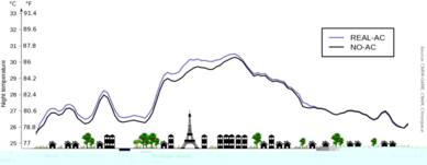
Parisian temperatures appeared to average upwards of 10°F warmer in heavily built areas versus immediately adjacent green space. The trend has led to an ongoing revolution of how contemporary designers can better integrate natural systems within the urban environment to holistically address several sustainability issues, including mitigating the urban heat island effect.
HOW UAVs ARE HELPING US COMBAT THE URBAN HEAT ISLAND EFFECT
Last year SmithGroup invested in two state-of-the-art UAVs (drones), including one that is equipped with a hi-res thermal camera. This equipment delivers stunning hi-res thermal imagery as it simultaneously captures hi-res 3D photogrammetry, and does so on UAVs capable of replicating saved flightpaths within 1cm.
The thermal camera was acquired for building inspections, but I saw an opportunity to visually demonstrate how our design solutions directly mitigate the urban heat island effect by scanning a project pre-installation, then scanning the same project again identically, post-installation, in order to see the difference we made. The concept also revealed broader implications to recalibrate design strategies for the maximum possible impact in preventing the urban heat island effect.
In the Spring of 2019, SmithGroup announced an exciting grant opportunity for employees to pursue big ideas. I applied and was fortunate to secure resources to explore this nascent endeavor.
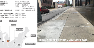
The pilot project identified for this study was an active urban streetscape revitalization in downtown Ann Arbor, Michigan, and a project that I helped design at SmithGroup. The existing street was exposed, barren concrete, but will soon become a vibrant streetscape.
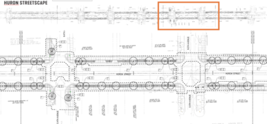
The proposed streetscape includes traffic calming measures, pedestrian amenities, as well as 130 large new shade trees. The City of Ann Arbor is nicknamed “Tree City,” and administrative officials fittingly made trees a priority within the project corridor by investing heavily in larger 4-inch caliper shade trees for immediate impact post-installation. A range of urban tolerant tree species were specified to avoid monocultures and create visual interest.
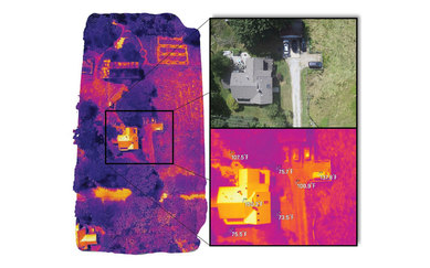
SmithGroup pilots undertook professional UAV training in January 2019, and professional thermal UAV training in June 2019. Following that, I began training independently with the thermal camera at my extended family’s farm. During a successful training scan (above) the air temperature measured 81°F. Notice the asphalt shingle rooftop’s temperature measured over 150°F in the snapshot enlargement. At the same time surface temperatures measured nearly 80°F lower under existing shade trees barely 10 feet away.
This training mission was simple. The farm is about 30-acres of gently sloping rural farmland – a great place to fly tens of thousands of dollars in equipment hundreds of feet in the sky. The real test would be the urban canyon.
This is the beginning; the first chapter in what will unfold in coming months and years as data and forthcoming analyses reveal more. The next installment of this series will launch into how the urban canyon was captured from the sky. Want to see more? Follow SmithGroup on LinkedIn and Twitter to be part of the conversation.